Sunday, September 30, 2012

BLOG 24. New WP Bag From Piragis by Cliff Jacobson

 BLOG 24 . New WP Bag From Piragis by Cliff Jacobson

I once asked the late Calvin Rutstrum what he thought of synthetic sleeping bags, which dry fast if they get wet. I knew Rutstrum preferred down bags so I expected a baited response. His answer? “Cliff, experienced paddlers donʼt get their sleeping bags wet on canoe trips. If you know how to camp and canoe, you wonʼt either!” I could have cheered!

In my writings, Iʼve hammered home that “skills are more important than things”. After all, if you can avoid the accident you wonʼt have to treat it. Still, bad stuff happens. Once, my tundra camp was pelted by driving rain and sustained winds of 60 miles an hour (we had a wind gauge), for three days. Our tents held; nothing got wet. On a wilderness canoe trip to James Bay in 1972, my canoe capsized while it was being lined around a ledge. Our packs were soaking wet but the contents were dry. Hood River, 1992: Susie and I were napping (in our canoe) in an eddy above a narrow rapid, waiting for our turn to run. Suddenly, the current caught the stern and seconds later we were upside down. We were rescued quickly; everything in our packs was bone dry.

Before the days of dry bags, waterproofing consisted largely of packing by the “sandwich method” described in my books. Basically, you start by stuffing the item into a nylon stuff sack (which need not be waterproof). This stuff sack is placed inside a waterproof plastic bag—the bag should be twice the length of the stuff-sack. You twist (spindle) the mouth of the plastic bag, fold it over and secure it with a bungee cord. This (now waterproof) unit goes inside an over-sized nylon stuff sack. Note that the waterproof layer (the plastic bag) is sandwiched between tough nylon on each side. This system is 100 percent reliable. A similar procedure, using two giant 6 mil thick plastic bags, is used to waterproof large portage packs. However, 6-mil bags donʼt “twist, and bungee” as easily as lighter bags, so the best procedure is to separately roll down the mouth of each bag then buckle the pack-flap tightly enough to compress the rolled plastic liners below. The liner bags must be compressed to be water-tight. The negative is that you need a nearly full pack to maintain sufficient pack-flap compression.
 Cooke Custom Sewing Pioneer pack and Piragis waterproof liner bag

Enter the new bright yellow “Piragis nylon Waterproof Pack Liner”. Constructed from PVC-free, urethane-coated nylon (with welded seams), this heavy-duty waterproof bag measures 48 inches high by 29 inches wide. This is big enough to fill out the largest portage pack. A rectangular bottom uses space efficiently. The classic roll-and-Fastex buckle closure is quick and secure. When sealed, the liner is completely watertight—no need for compression. The coated nylon fabric is cold-flexible and very tough. This said, Iʼm a belt-and-suspenders man so I always place a 6-mil plastic liner bag INSIDE the waterproof pack liner to take the abrasion that comes from stuffing things into the yellow bag. A plastic liner bag prevents damage to the waterproof coating of the yellow bag when you stuff.
Green River, Utah.  Note yellow waterproof bags and plastic liners

The Piragis Waterproof Pack Liner is an excellent product; I heartily recommend it!

Cliff Jacobson
www.cliff-jacobson.com


Saturday, September 22, 2012

BLOG 23.Backwoods Cops and Common Sense, by Cliff Jacobson

BLOG 23. BACKWOODS COPS AND COMMON SENSE
by Cliff Jacobson


It began at one of Rutabaga’s famed “Canoecopia” events.  I stopped to chat with Larry Laba, CEO of SOAR inflatables.  Larry had a bone to pick with my book, “Expedition Canoeing”, in which he said I had included every type of canoe, except his. 

I told Laba I didn’t think SOAR’s were “real” canoes.”  At this, Laba launched into a dissertation, politely suggesting that I was largely out-to-lunch.  I listened quietly and promised to eat crow and try a SOAR.  Someday.
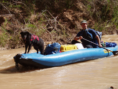
SOAR (Somewhere on a River) boat

Someday came in 2003 when Laba received a hard-to-get permit to canoe the Gates-of-Ladore section on the Green River, which runs through Dinosaur National Monument.   Ten select paddlers, including Susie and I, were invited to go. We’d paddle SOAR boats, of course. 

Susie and I had never paddled a canyon river, or one with such large rapids.  We figured it would be quite a rush.  Larry warned us at the start that there were lots of regulations we would have to follow.  And, that the slightest violation would be prosecuted.
Campsite along the Green River


I vowed to keep an open mind and a willing smile.  I’d heard the Gates-of-Ladore was spectacular, and well worth the high (regulatory) price of admission.

TROUBLE AT THE OUTSET
Trouble surfaced immediately.  It was nearly noon on June 10 on the appointed
put-in day when part of the crew arrived with the unhappy news that Laba’s truck had broken down (with all the boats) near Salt Lake City.  It would be 5 PM, at the earliest before he and the rest of the crew would arrive. 
Campsite along the Green River

RANGERS TO THE RESCUE
We shared our concern with a park ranger, who we’ll call Ranger #1 (keep track; there are four more).  Could we try plan B?  Say, leave around 7 PM that night and take a “closer” campsite than the one (16 miles downstream) for which we were scheduled?  Ranger #1 radioed for advice.  No luck; the closer site (six miles ahead) was taken.  Our choice was to wait  for Laba then plow on through that night, or start the next morning.

Five PM passed.  No Laba.  And now, there was a 30 mile per hour wind blowing upstream.  The run to our first scheduled campsite contained some tough rapids (Class III-IV).  We agreed it would be best to begin tomorrow and make up lost time.  Ranger #1 had gone for the day.  In his place was Ranger #2, a pleasant young woman with a willing smile.

“Would it be okay if we start tomorrow and make up lost time?
“Yes,” she said.  “But you will have to camp at your assigned site for June 11.”
That seemed fair enough to us.

Laba showed up the following morning, and by noon we had done the shuttle and were off.  We pulled into our scheduled campsite around six.  There was a ranger (#3) standing on the shore to greet us.  He asked to see our permit, then he fired off a barrage of questions:
Being questioned by a ranger!

“Do you have a groover?  A food-strainer? First-aid kit? Extra PFD?  Throwing rope? Fire-pan?  Everyone have helmets?  Admittedly, I’m used to the freedom of Canadian rivers—where I can camp when and where I please, and where safety and land ethics are an individual responsibility I take seriously--so I wasn’t quite prepared for this grilling.  Still, given the heavy use (sans abuse) of this river, I welcomed his questions and I appreciated his professional demeanor.  
           
Day three ended just like day two.  Ranger #4 stepped out of the bush just as our boats touched land. He told us he had radioed Ranger #3 about us, so he downplayed the questions about our preparedness and focused on other matters.
            
Now, I should make it perfectly clear that I understand—and value--the need for regulating high-density rivers like the Green—and for checking boaters who are sometimes irresponsible and unprepared.   Yes, serious rules are in order for heavily used rivers like the Green, and I am pleased to follow those rules and be quizzed about them. Still, we had encountered two rangers on two successive days-- and they were waiting at the campsites for us!  Was big brother watching, or what?
           
The next day’s “rapid experience” was wonderful—that is, until we arrived at the take-out, right on schedule.  A serious-looking, middle-aged ranger (#5) was there,  checking permits.  He had a gun!
           
Ranger #5 looked briefly at our permit then pulled out a pad and proceeded to write Laba a fine for 25 dollars.  For what?

“You started on June 11.  This permit is for June 10.”  
What the hey?

We pointed out our conversation with Rangers #1 and #2, who had advised us to leave on the 11th and make up lost time.  The gunman didn’t look up—just kept writing.

            I was ticked.  Real ticked!
             “So what are you trying to prove here, officer?” I asked, my face right in his.
            “Careful, Cliff, this guy’s got a gun,” whispered Laba.
“Yeah, yeah.  So tell me, officer, should we have left in total darkness on the 10th? Paddled those big rapids and drowned?   R..e..a..l..l..y, officer, what would you have us do? 
           
The gun-guy said he had checked with rangers #3 and #4 and he “knew all about us.”  Yeah, ten bank robbers in paddling duds, rushing down the river.  Hop your horse and bust ‘em at the take-out!  

The Ranger kept writing.  “Just doing my job, following the law.  My name is Ranger Dah dah; my supervisor’s name is Mr. Dah dah.  Tell it to the judge!”  Yeah!

I raved on that I had guided canoe trips in the Boundary Waters Canoe Area and northern Canada for more than three decades and had never seen such an abuse of power by a figure in authority.  Then, I turned about face and walked out of the picture, leaving my friends to smooth my ruffled path.
           
When Susie and I returned to the Gates-of-Ladore campsite to pick up our car we ran into the lady ranger (#2), who had been so helpful.  She was very sympathetic and questioned why we were ticketed when we had shared our options with her (and ranger #1) and had inconvenienced no one during our trip.  It was a bum wrap; she would tell her supervisor.

THE AFTERMATH
           
Bureaucracies fuel bureaucracies, so naturally, the fine remained.  As for me, there is a bitter knife that stabs deep into the core of my soul.  Yes,  we do need rules that protect the environment from us, and us from one another.  But we also need public servants who enforce those rules with compassion and rational thought.  Rangers #1 through #4 live their lessons; ranger #5 needs some common sense and a tome on tact.
           
What bothered me most about canoeing the Green was not the rules, which were justifiable.  It was the “in your face attitude” of the rangers and, in my view, an underlying assumption that we were out to do wrong.  By comparison, Minnesota’s Boundary Waters Canoe Area sees the paddles of a quarter million canoeists each year, thousands more than The Gates-of-Ladore.  Yes, there are rules—tough ones: “Camp only at existing sites; no bottles or cans allowed; maximum party size of nine; make fires (when permitted) in approved fire-grates; use established box latrines; don’t cut living trees, and clean up as to leave no trace of your presence. You are  given a “numbered” trash bag that you are expected to fill (with your trash and that of others) and to pack out.

By and large, the rules are willingly honored.  Pull into any one of the hundreds of BWCA campsites and you will find no evidence of passing paddlers—no trash, no garbage, nothing. The premise is that paddlers want to do right, and will do what’s right if they know what’s right!  Education (with a smile) is top priority.  Check into any Boundary Waters permit station and you’ll see a film and take a quiz on wilderness ethics and, you’ll be pleasantly lectured by a Forest Service ranger. 

Yes, there are tickets issued, but only for gross violations—unattended fires, axe-hacked trees, ditched tents, obnoxious noise, etc.  More often than not, ignorance is   rewarded with a friendly lecture or a lesson by example.  Beginners learn the ropes and develop a positive attitude.
           
Example: Many years ago I watched a man at a Boundary Waters campsite wash dishes in the lake. A small, but determined, raft of suds blew my way.  I was about to jump into my canoe, cuss words flying, when I remembered the old cliché that you can catch more bears with honey than guns.  So I forced a smile and pleasantly paddled his way.
           
When the man saw me, he waved and invited me in for coffee.  He was a really nice guy!  For an hour I shared his fire and hospitality.  I tactfully told him how organic wastes increase bacterial levels in water; how improperly disposed-of feces leach into lakes; how fires can creep underground and spring to life hundreds of yards away. 
           
We had quite a talk, he and I.
           
Afterwards, the man thanked me for the lecture.  He said he would never make the same mistakes again.  And, he would spread the word.  We parted friends, he and I.
           
Now, suppose I had been a Forest Service ranger and had simply given the man a big fat fine?  Attitude check for future trips?  Go figure.

I wish ranger #5 and I could have had a nice long talk, away from the crowd and the badge.  Perhaps then, he would have questioned his judgment and we too, could have parted friends.
           
On a more positive note: The river was beautiful; the rapids were great—and yes, Mr. Laba, your SOAR boats are indeed very real canoes—and the right medicine for big pushy rivers. Sorry I missed your boat in my book.

 ADDENDUM
One of the guys in our crew was a lawyer who knew whom to call and what strings to pull.  So a month later the ticket was  pleaded down to "Cutting timber on government land" and the 50 dollar fine was dismissed.  It's interesting to note that here are no trees along the Green River, at least not ones that are big enough to cut.

Cliff Jacobson
www.cliff-jacobson.com


Tuesday, September 18, 2012

Final West Zone Boundary Waters Update Sept. 18, 2012


 Superior National Forest Fire Update
Sept. 18, 2012
Final Update


Special Notifications:  This is a Final Update.  Future updates will only be provided in the event of any new fires occurring or if there is a change in closures or restrictions. 
Fire restrictions remain in effect in the entire Boundary Waters Canoe Area Wilderness. Campfires are allowed only between 7 p.m. and midnight. Lake and portage closures related to the Hoist Bay Fire and the Parley Fire were lifted on 9/17/12.

Current Fire Activity:  

Parley Lake Fire, 35 acres, T66 R12 S18, within the BWCAW along the Beartrap River, was discovered Sept 12.  100% containment was reached by early evening on 9/16/12.  Fire crews are making good progress mopping up and taking care of hazard trees. Closures are lifted. Campfire restrictions remain in effect. 

Fort Frances #53, also known as the Norway Point Fire, 52 acres, remains on Canadian soil and is being monitored by Quetico and U.S. personnel.

Fort Frances #59/Emerald Lake Fire, between Knife Lake and Emerald Lake. The fire remains on the Quetico side and is currently smoldering and has a few pockets of fire.  Due to Canadian mapping, this fire is at 720 acres.  Forest Service crews are monitoring this fire and are prepared to actively support Canadian fire crews as needed. A closure has been put in place on the U.S. side to ensure visitor safetyClosure:  From the US/Canadian border heading south along the section lines of T65N, R7 W, sections 21 and 28, including all campsites on islands and peninsulas on adjacent lands, the following lakes, portages, and campsites are closed:  from the US/Canadian border on Knife Lake to the east end of Swamp Lake, South Arm of Knife Lake, Little Knife Lake, Amoeber Lake, Topaz Lake, Cherry Lake, Hanson Lake, Clam Lake, Lunar Lake, Lake of the Clouds, Rivalry Lake,  Gijikiki Lake, Ester Lake, Ottertrack Lake, Rabbit Lake, Ashdick Lake, and Swamp Lake.  Portages from South Arm of Knife Lake to Bonnie Lake, South Arm of Knife Lake to Sema Lake, South Arm of Knife Lake to Eddy Lake, Swamp Lake to Saganaga Lake are closed.  Northbound travel from Bonnie Lake, across the Bonnie Lake to South Arm Knife Lake portage, and west bound transit through the South Arm Knife Lake to Knife Lake and out of the closure area is allowed.  Closure signs will be posted.

Resources Available: A total of 170 people are assigned or available on stand-by.  Forest Service and contract fire engines, Forest Service Beaver float planes, one Type 2 and one Type 3 helicopters are assigned to fire operations.  CL215s and more helicopters are available if needed.

Polly Lake Fire, T63N R6E S34 on the East Zone, estimated at one to two tenths of an acre is a new fire detected 9/16/12.  It remains in patrol status.

Mora Lake Fire on the east side of the forest, detected on 9/12, size revised to 3 acres.  The fire is 100% contained.  Aircraft will continue to patrol the fire.

Controlled Fires: 
Cummings Lake Fire, located at T64 R14 Section 28, BWCAW, was declared ‘controlled’ on 9/12/12.  The control line is holding and no reported smoke has been observed on this fire since 9/12/12.  The fire will be patrolled until declared out.  Colby Lake Fire, a half-acre fire near Hoyt Lakes, was detected and controlled on 9/13/12 and remains in patrol status.   Little Devil Fire, at T61N R1E S12, a 1/10 -acre fire outside the BWCAW near Grand Marais, was detected 9/15/12, quickly controlled, contained, and remains in patrol status. Peterson Lake Fire on the east side of the forest near Horn Lake: T 62 R4 S14, SW of the NW, detected 9/12.  Size is one quarter acre. This fire is contained and controlled.   Patrols will continue by aircraft. Windy Lake Fire, was a new fire detected 9/15/12 on the east side of Windy Lake, T61N, R6W, S26.  Crews immediately responded and controlled the fire at 1/10 acres.
 
Fires that are out:
Hoist Bay Fire, 2 1/2 acres within the BWCAW, T64 R10 S17, between Hoist and Back Bay of Basswood Lake was declared out 9/17/12 afternoon. Closures are lifted.  Campfire restrictions remain in effect.

Season Summary: 
In addition to the active fires listed above, crews have put out 11 fires since the beginning of September. Of a total of 54 fires during 2012, 32 were human caused and 22 were caused by lightning. The total acreage burned by wildfire as of 9/17/12 is 315.

Monday, September 17, 2012

Boundary Waters Fire Info Monday, Sept. 17, 2012


Superior National Forest Fire Update
Sept. 17, 2012


Special Notifications:  Rain predicted for the area yesterday did not materialize. Fire restrictions remain in effect in the entire Boundary Waters Canoe Area Wilderness. Campfires are allowed only between 7 p.m. and midnight. Lake and portage closures related to the Hoist Bay Fire and the Parley Fire will be lifted today.

Current Fire Activity: 
Parley Lake Fire, 35 acres, T66 R12 S18, within the BWCAW along the Beartrap River, was discovered Sept 12.  100% containment was reached by early evening on 9/16/12.  Fire crews will continue to reinforce fire lines. Closures are lifted. Campfire restrictions remain in effect.

Hoist Bay Fire 2 1/2 acres within the BWCAW, T64 R10 S17, between Hoist and Back Bay of Basswood Lake was declared out yesterday afternoon. Closures are lifted.  Campfire restrictions remain in effect.

Fort Frances #53, also known as the Norway Point Fire, 52 acres, remains on Canadian soil and is being monitored by Quetico and U.S. personnel.

Fort Frances #59/Emerald Lake Fire, between Knife Lake and Emerald Lake, is estimated at 525 acres, and continues to be active. The fire remains on the Quetico side.  Forest Service crews are monitoring this fire and are prepared to actively support Canadian fire crews as needed. A closure has been put in place on the U.S. side to ensure visitor safety.  The fire did not receive any precipitation last night. Closure:  From the US/Canadian border heading south along the section lines of T65N, R7 W, sections 21 and 28, including all campsites on islands and peninsulas on adjacent lands, the following lakes, portages, and campsites are closed:  from the US/Canadian border on Knife Lake to the east end of Swamp Lake, South Arm of Knife Lake, Little Knife Lake, Amoeber Lake, Topaz Lake, Cherry Lake, Hanson Lake, Clam Lake, Lunar Lake, Lake of the Clouds, Rivalry Lake,  Gijikiki Lake, Ester Lake, Ottertrack Lake, Rabbit Lake, Ashdick Lake, and Swamp Lake.  Portages from South Arm of Knife Lake to Bonnie Lake, South Arm of Knife Lake to Sema Lake, South Arm of Knife Lake to Eddy Lake, Swamp Lake to Saganaga Lake are closed.  Northbound travel from Bonnie Lake, across the Bonnie Lake to South Arm Knife Lake portage, and west bound transit through the South Arm Knife Lake to Knife Lake and out of the closure area is allowed.  Closure signs will be posted.

Resources Available: A total of 180 people are assigned or available on stand-by.  Forest Service and contract fire engines, Forest Service Beaver float planes, one Type 2 and two Type 3 helicopters are assigned to fire operations.  CL215s and more helicopters are available if needed.

Polly Lake Fire, T63N R6E S34 on the East Zone, estimated at one to two tenths of an acre is a new fire detected 9/16/12.  It remains in patrol status.

Mora Lake Fire on the east side of the forest, detected on 9/12, size revised to 3 acres.  The fire is 100% contained.  Aircraft will continue to patrol the fire.

Controlled Fires:
Cummings Lake Fire, located at T64 R14 Section 28, BWCAW, was declared ‘controlled’ on 9/12/12.  The control line is holding and no reported smoke has been observed on this fire since 9/12/12.  The fire will be patrolled until declared out.  Colby Lake Fire, a half-acre fire near Hoyt Lakes, was detected and controlled on 9/13/12 and remains in patrol status.   Little Devil Fire, at T61N R1E S12, a 1/10 -acre fire outside the BWCAW near Grand Marais, was detected 9/15/12, quickly controlled, contained, and remains in patrol status. Peterson Lake Fire on the east side of the forest near Horn Lake: T 62 R4 S14, SW of the NW, detected 9/12.  Size is one quarter acre. This fire is contained and controlled.   Patrols will continue by aircraft. Windy Lake Fire, was a new fire detected 9/15/12 on the east side of Windy Lake, T61N, R6W, S26.  Crews immediately responded and controlled the fire at 1/10 acres.

Season Summary:
In addition to the active fires listed above, crews have put out 10 fires since the beginning of September. Of a total of 54 fires during 2012, 32 were human caused and 22 were caused by lightning. The total acreage burned by wildfire as of 9/15/12 is 315.

Friday, September 14, 2012

Boundary Waters Fire Closures Update with Maps Sept. 13, 5:30 P.M.


Superior NF Fire Press Release

Please note: the closures associated with Knife Lake are included in this release.
DATE: September 13, 2012

A series of small wildfires are currently burning in or adjacent to northern parts of the Boundary Waters Canoe Area Wilderness (BWCAW).  In light of this fire activity and projected weather, the Forest Service is closing some lakes and surrounding areas to protect public safety.

The following lakes, campsites, and portages within the Boundary Waters Canoe Area Wilderness are closed:

Related to Hoist Lake Fire
Four Mile Portage, Ella Hall, Mud Lakes, Slumber, and Muskeg Lakes and campsites; the waters and campsites of Hoist and Back Bays of Basswood Lake, the portages from Pipestone to Back Bay, Back Bay toward Half Dog Island (a.k.a. Frog Portage), and from Hoist Bay to Good Lake.
Click Map for Larger image


Related to Parley Lake Fire
Sunday and Saturday Bay Campsites in Crooked Lake; Zones 5, 1, and 2 of the Sundial Primitive Management Area—all the lakes and waterways within that area including: the Beartrap River from Beartrap Lake north to Iron Lake, Parley, Sunday, Sundial, Bunggee, Sinneeg, and Ritual Lakes ; Travel will be allowed through the bays of Crooked Lake but camping will not be allowed on Sunday and Saturday Bays; Travel will NOT be allowed on the Beartrap River.
Click Map to view Larger Image


Related to Emerald Lake Fire (fire is on Canadian side of border)
From the US/Canadian border on Knife Lake to the end of Ottertrack Lake, South Arm of Knife Lake, Little Knife Lake, Amoeber Lake, Topaz Lake, Cherry Lake, Hanson Lake, Lunar Lake, Lake of the Clouds, Rivalry Lake, Gijikiki Lake, Ester Lake, Ottertrack Lake, Rabbit Lake, Ashdick Lake.  This includes area from the US/Canadian border heading south along the section lines of T 65 N, R 7 W, sections 21 and 28, including all campsites on islands and peninsula on adjacent lands, the following lakes, portages, and campsites. 

For updates regarding closures and restrictions, please see the Superior National Forest website:   www.fs.usda.gov/superior

For information about active wildfires, see: www.inciweb.org

Thursday, September 13, 2012

Boundary Waters Fire Update CLOSURES Sept. 13, 1:00 p.m.


West Zone Fire Update
                                                                                      Ely, MN
                                                                          Sept. 13, 2012 1:00 p.m. 
   

Special Notifications:  Various closures are in effect due to the Parley Fire and the Hoist Bay Fire. Please see the details below.  Public Safety crews are posting these areas.  Also, fire restrictions remain in effect in the Boundary Waters Canoe Area Wilderness. Campfires are allowed only between 7 p.m. and midnight.

Current Fire Activity: 

Parley Lake Fire, is estimated at 75 acres, in the BWCAW, T66 R12 S18, east of the Beartrap River, north of Sunday Lake, west of Sunday Bay of Crooked Lake, discovered Sept 12. Aircraft are continuing water drops. A ground crew is on scene.
Closures:  Campsites on Sunday and Saturday Bays of Crooked Lake, the Beartrap River, and Zones 1, 2, and 5 of the Sundial Primitive Management Area are closed. Travel throughSunday and Saturday Bays is still being allowed.

Hoist Bay Fire: approximately 2 1/2 acres, T64 R10 S17, between Hoist and Back Bay of Basswood Lake. This fire was detected at 5:40 pm on 9/12/12. Type 2 Helicopters and CL215s dropped water until dark.
Closures:  Four mile portage, Ella Hall, Muskeg, Slumber, and Mud Lakes (out of Fall Lake) plus Back Bay and Hoist Bay of Basswood.  Additional portage closures include Pipestone to Back Bay, Back Bay toward Half Dog Island/Basswood, and from Hoist Bay to Good Lake.  Public Safety crews are notifying visitors in the area.

Fort Frances #53, also known as the Norway Point Fire remains on Canadian soil and is being monitored by Quetico and U.S. personnel.

Fort Frances #59, between Knife and Emerald Lake, approximately 300 acres, is also very active. The fire remains on the Quetico side and is also being closely monitored on both sides.

Peterson Lake Fire on the east side of the forest near Horn Lake: T 62 R4 S14, SW of the NW is one quarter acre. The FS Beaver is dropping water on it.

Resources Available: Forest Service Fire Engines, approximately 30 personnel. Aircraft in Ely include three Forest Service Beaver float planes and one Cessna on floats, two Type 2 helicopters, and a Type 3 helicopter.  CL215s and more helicopters are available if needed.
Controlled Fires:
Cummings Lake Fire: T64 R14 Section 28, BWCAW; declared ‘controlled’ on 9/12/12. The fire line is holding well but the fire will not be out without significant rain or snowfall. This fire will be monitored by both ground and air crews.
Camp Lake Fire is one tenth of an acre. Declared ‘controlled’ on 9/12/12.


Fires Suppressed and Declared Out:
The Batista Fire near Batista Lake, Township 66, Range 13, the northeast corner of Section 9—east of (U.S.) Agnes and west of Iron Lake, was declared out this afternoon. Wooden Leg Fire (T64 R9 Section 13: -91 25.43, 48 01.42) out yesterday: The lake, portage, and trail closures associated with this fire are lifted. Fire restrictions (fires only between 7 p.m. and midnight) are still in effect in this area as well as within the entire BWCAW.
Birch Lake #2 Fire was fought by Forest Service, Morse/Fall Lake, and Babbitt Fire Departments. The fire is declared ‘out’ at one tenth of an acre.
8 other fires were declared out between September 6th and 10th.

Closures Now in Boundary Waters due to Fire


September 13th 8:45 a.m.

New Update from the West Zone Fire Information Desk.

We are closing campsites on Sunday and Saturday Bay of Crooked Lake and the Beartrap River through Zones 1, 2, and 5 of the Sundial PMA.

We are closing the Four Mile Portage, Ella Hall, and Mud Lake (out of Fall Lake) plus Back Bay of Basswood.  Portage closure are the 70 rod from Pipestone to Back Bay, the 90 rod from Back Bay toward Half Dog Island/Basswood, and the 68 rod from Hoist Bay to Good Lake.

Closures are for the camper's safety and for the safety of the fire fighters.

this is due to yesterday's activity summarized below:

West Zone Fire Update
                                                                                      Ely, MN
                                                                          Sept. 12, 2012 afternoon
   

Special Notifications:  The stiff winds increased fire activity today. Fire restrictions remain in effect in the Boundary Waters Canoe Area Wilderness. Campfires are allowed only between 7 p.m. and midnight.

Current Fire Activity: 

Parley Lake Fire, is estimated at 75 acres, in the BWCAW, T66 R12 S8, east of the Beartrap River, north of Sunday Lake, east of Sunday Bay of Crooked Lake, discovered today. This fire is receiving water drops from a medium helicopter and CL215s today. A ground crew will be on scene soon. Campsites on Sunday Bay of Crooked Lake and the Sundial Primitive Management Area will be closed to secure public safety and allow fire fighters ample room to work.

Hoist Bay Fire: approximately one acre, T64 R11 S17, between Hoist and Back Bay of Basswood Lake, discovered at about 5:40 p.m. CL215s are on the way. Public Safety crews are going in by motor boat.


More Boundary Waters Fires on September 12, 2012


Thursday Morning 8:45
New Update from the West Zone Fire Information Desk.


We are closing campsites on Sunday and Saturday Bay of Crooked Lake and the Beartrap River through Zones 1, 2, and 5 of the Sundial PMA.

We are closing the Four Mile Portage, Ella Hall, and Mud Lake (out of Fall Lake) plus Back Bay of Basswood.  Portage closure are the 70 rod from Pipestone to Back Bay, the 90 rod from Back Bay toward Half Dog Island/Basswood, and the 68 rod from Hoist Bay to Good Lake.

Closures are for the camper's safety and for the safety of the fire fighters.

West Zone Fire Update
                                                                                      Ely, MN
                                                                          Sept. 12, 2012 afternoon
   

Special Notifications:  The stiff winds increased fire activity today. Fire restrictions remain in effect in the Boundary Waters Canoe Area Wilderness. Campfires are allowed only between 7 p.m. and midnight.

Current Fire Activity: 

Parley Lake Fire, is estimated at 75 acres, in the BWCAW, T66 R12 S8, east of the Beartrap River, north of Sunday Lake, east of Sunday Bay of Crooked Lake, discovered today. This fire is receiving water drops from a medium helicopter and CL215s today. A ground crew will be on scene soon. Campsites on Sunday Bay of Crooked Lake and the Sundial Primitive Management Area will be closed to secure public safety and allow fire fighters ample room to work.

Hoist Bay Fire: approximately one acre, T64 R11 S17, between Hoist and Back Bay of Basswood Lake, discovered at about 5:40 p.m. CL215s are on the way. Public Safety crews are going in by motor boat.

Fort Frances #53, also known as the Norway Point Fire, put up a lot of smoke this afternoon, worrying residents on Snowbank and Moose Lake. The fire remains on Canadian soil and is being monitored by Quetico and U.S. personnel.

Fort Frances #59, between Knife and Emerald Lake is also very active today with smoke running parallel to the shore of Knife Lake. The smoke caused concern along the Gunflint Trail. The fire remains on the Quetico side and is also being closely monitored on both sides.

Birch Lake #2 Fire was fought by Forest Service, Morse/Fall Lake, and Babbitt Fire Departments today. The fire was declared out at one tenth of an acre.

Peterson Lake Fire on the east side of the forest near Horn Lake: T 62 R4 S14, SW of the NW is one quarter acre. The FS Beaver is dropping water on it.

Resources Available: Forest Service Fire Engines, approximately 30 personnel. Aircraft in Ely are two Beaver float planes, a Sikorsky Type 2 helicopter, and a Type 3 helicopter.  CL215s and more helicopters are available if needed.

Controlled Fires:
Cummings Lake Fire: T64 R14 Section 28, BWCAW; declared controlled today. The fire line held well under windy conditions but will not be out without significant rain or snowfall. This fire will be monitored by both ground and air crews.
Camp Lake Fire is one tenth of an acre. Discovered yesterday and declared controlled this afternoon.

Fires Suppressed and Declared Out:
The Batista Fire near Batista Lake, Township 66, Range 13, the northeast corner of Section 9—east of (U.S.) Agnes and west of Iron Lake, was declared out this afternoon. Wooden Leg Fire (T64 R9 Section 13: -91 25.43, 48 01.42) out yesterday: The lake, portage, and trail closures associated with this fire are lifted. 

Fire restrictions (fires only between 7 p.m. and midnight) are still in effect in this area as well as within the entire BWCAW.
8 other fires were declared out between September 6th and 10th.

Wednesday, September 12, 2012

BLOG 22. Body Sensors--A New Synthetic That Works!

BLOG 22. A New Synthetic That Works!
by Cliff Jacobson

At the outset, I should make it perfectly clear that I’m a “wool” man, and it would take an act of congress or a seriously enlightening experience to get me to swap my beloved merino wool base layers for synthetics. This said, there are synthetics that work well.  One, that has been around for years, is Thermax® which is made from polyester fibers.  Thermax® has a decent temperature comfort range, it insulates when wet, it’s soft against the skin, non-allergenic and it doesn’t smell like a dirty old sweat sock as the days go by. In the days before merino wool, my wife Susie swore by it. She said it was the only long underwear that didn’t smell over the long haul.

But now there’s a new kid on the block which earns high marks.  It’s called Body-Sensors® by Terramar©. There are three thicknesses—warm, warmer and warmest. The lightweight stuff feels and drapes like silk. The heavyweight has a cozy, fleece-like feel. The fabric is super soft and comfortable. Here’s the corporate shtick as written on the package:

“TXO (Advanced Odor-control Technology) performance baselayers incorporate advanced X-Odor® moisture and odor technology featuring activated carbon and embedded nano-silver for long lasting odor control and fast drying.“  The silver, of course, kill microbes; the carbon absorbs odors. 
Heavyweight with zip neck


Fabric features:
·      Knit with hollow core polyester yarn for added insulation for warmth without excess bulk.
·      Flat seam construction for comfort and durability.
·      Soft 2-sided fleece for the ultimate comfort.
·      UPF 50+
·      Eco-friendly no chemical finishes.
Lightweight/crew neck
To this, I would add, “luxuriously soft, silk-like draping quality, wide temperature comfort range and very light weight”.  In mid-May, I drove my little red roadster (1996 BMW Z-3) to Los Angeles to visit my daughters, then I took the northern route over Donner Pass back home.  Except for two hours of rain on the drive out, the top was down all the time.  Temperatures averaged in the eighties, with a long spike of 104 in Arizona.  A lightweight Body-Sensor shirt was my primary upper garment for most of the route.  Only when the temperature reached 100 was I too hot, and this was probably more due to the heat-absorbing black color of the fabric than to the insulation.  The UV protection worked as advertised—there wasn’t a hint of sun-burn on my upper body.  I wore the Body-Sensor lightweight upper for several hours each day for six days, and I never washed it.  When I reached LA, it was still odor-free.  That’s impressive.
Cottonwood Pass/Continental Divide, Colorado.  Cliff with 1996 BMW Z3


While driving home over Donner Pass, I encountered heavy fog.  My car thermometer read 38 degrees and the sky looked pretty nasty.  I was wearing two Body-Sensor layers—light and medium weight—under a porous wind shirt. The convertible top was down, as usual, and cars were backed up because of the poor visibility. Then came rain with a mix of snow. Generally, as long as I’m going over 50 mph, with the side windows and wind-screen up, the rain largely goes over the car. Slow down below 50, and the car becomes a swimming pool. Putting the top up on the old Z3 is a 30 second hassle, which, in a hard rain is time enough to flood the car. So I usually just keep driving, hoping for a covered spot where I can pull off and work out of the rain. No luck. I drove on at around 40 mph for about 15 minutes.  When I finally found a covered gas station, the car and I were soaking wet, but surprisingly, I was not chilled.  As I put up the top and turned the heater to full blast I remember thinking, “No kiddin’; this stuff really works!”

With the top up and the heater running, the lightweight Body-Sensor dried on me in about 5 minutes.  The heavier shirt, which was draped over the passenger seat needed 30 minutes more.

I can’t say if this stuff works as well as the merino wool I love and cherish, or if it will stand the test of time.  After a summer of use, there's some light pilling, that's all. The bottom line is that I do like it and I would trust it on a wilderness canoe trip.  As synthetics go, it earns high marks.

Cliff Jacobson
www.cliff-jacobson.com 


Tuesday, September 11, 2012

Boundary Waters Closures Lifted -- FIRE RESTRICTIONS STILL IN EFFECT


West Zone Fire Update
                                                                                      Ely, MN
                                                                          Sept. 11, 2012 noon
   

Special Notifications:  The warm, dry, and windy conditions continue. A fire restriction for the entire BWCAW remains in effect, allowing visitors to have campfires only at night from 7:00 pm to midnight.  Gas and propane stoves are permitted anytime.

Current Fire Activity: 
The Batista Fire near Batista Lake, Township 66, Range 13, the northeast corner of Section 9—east of (U.S.) Agnes and west of Iron Lake, received water drops by the Forest Service floatplane and Sikorsky Type 2 helicopter yesterday. A crew was flown in this morning and more bucket work will be done by the helicopter.

Fort Frances #53, also known as the Norway Point Fire, continues to burn in the Quetico. U.S. and Canadian crews are monitoring this fire. It is listed at approximately 40 acres.

Resources Available: Forest Service Fire Engines, approximately 30 personnel. Aircraft in Ely are two Beaver float planes, a Sikorsky Type 2 helicopter, and a Type 3 helicopter.  CL215s and more helicopters are available if needed.

Contained Fires:
Cummings Lake Fire: T64 R14 Section 28, BWCAW; crews anticipate calling this fire controlled after the line is tested today with dry, windy conditions.

Fires Suppressed and Declared Out:

Out on 9/11/12: Wooden Leg Fire (T64 R9 Section 13: -91 25.43, 48 01.42) BWCAW: declared out 9:30 a.m. today. The lake, portage, and trail closures associated with this fire are lifted. Fire restrictions (fires only between 7 p.m. and midnight) are still in effect in this area as well as within the entire BWCAW.

Out on 9/10/12: Rivard Fire, R 61, R 13, portions of Sections 23 and 24,

Out on 9/6/12: Beartrap Fire;
Out on 9/7/12: Cloquet Line, Hawk’s Nest, Thunder Lake, Spring CreekFire Lake, and Aikio Fires.

Followers